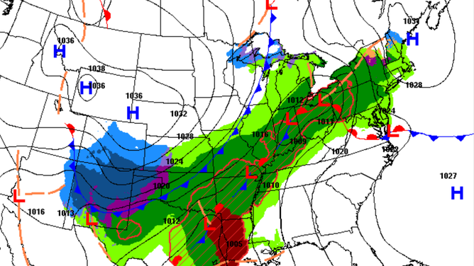
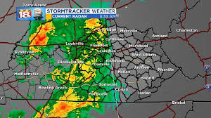
Over the past few days, Kentucky has had treacherous weather. These storms include heavy downpours, hail, lightning, and tornadoes. This weather could even have life-threatening flooding with major damage being done. This weather threat is the greatest Wednesday night into Thursday morning, however, more storms are possible late Thursday into Friday and could even last through the weekend. The National Weather Service has issued a flood watch until Sunday at 8 a.m. Kentucky can be expected to get around 10 inches of rain over the past few days.
With all this weather you can expect high winds up to 60 miles per hour, which means tornadoes are very likely over the course of the next several days. More thunderstorms are expected over the next several days as well. There could even be weather events called “supercell thunderstorms” around the London and Corbin area. There may be a break in all of these storms Friday evening and part of Saturday, but after that, it will probably start picking back up with the bad weather.
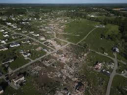
On April 3rd at around midnight, over 8,000 people were without power after the storm hit Louisville, KY. Many tornado warnings were spread across all of Kentucky. Even though this storm may sound awful for Kentucky, we are not even getting the worst of it. The worst being in Eastern Arkansas, Western Tennessee, Southeast Missouri, Western Kentucky, Southern Illinois, Northwest Mississippi, and Southern Indiana. For some states, it may just be some regular wind and rain, but for others, this can be some serious weather, and you may need to plan your safety route or even leave your house and go to a family member or friend’s house that has a basement to seek safety.
As of April 5th, the city of Falmouth was evacuated due to flooding. This is a developing story.