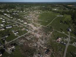
Here in Kentucky, there have been several back-to-back storms, from mere sprinkling rain to giant tornadoes. All the stagnation in the weather pattern has permitted storms to wreak havoc on the same areas. This leads to a lot of heavy rainfall and severe weather all around Kentucky. Places like London and Laurel have gotten the worst of it, having to recover after a EF4 tornado. But, the question nowadays, with all this destruction, is “why?”
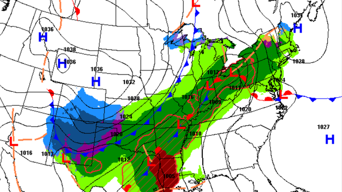
A possible answer to all this chaos is in the Gulf of Mexico. The Gulf has a lot of fuel for tornadic activity, which is moist, hot air. The storms are created when the hot air from the Gulf collides with the cool air from Canada. The results of the collision are mostly just west of the Appalachian Mountains, so oftentimes in Kentucky. The more moisture and heat a thunderstorm holds, the stronger and heavier it becomes. This issue gets even worse since the Gulf is getting warmer and warmer, as seen by its record breaking heats recorded in 2023 and 2024. Because the Gulf is getting hotter, it evaporates more, which means more moisture in the atmosphere, leading to more storms. They build off each other in a feedback loop. But do keep in mind that these storms aren’t set off by heat alone, it’s the cold front that pulls the trigger.
Although the Gulf isn’t the main culprit, there’s also pressure to consider. To elaborate, there’s ridges of high pressure centered over the east of the U.S.. These ridges have, in a way, trapped storm systems, which has prevented them from moving eastward. So, the region has been dealing with a stationary frontal boundary and areas of low pressure that are either slow-moving or stuck. So, this leads to storms repeatedly raining over the same areas. That amplifies the risk of flood watches and severe weather.